By Elodie Toto
Since he was old enough to work, Sam Elong has been a fisherman in Kribi, a coastal town of more than 90,000 inhabitants that stretches along the shore of the Gulf of Guinea at the mouth of the Kienké and Lobé rivers in Cameroon.
“Before, when we went fishing, we used to come back with 100-150 kg [220-330 pounds] of fish,” Elong tells Mongabay during a video call. “But over the last 10 years or so, since the port has been built, fish have been less easy to find … The construction of the port has made a lot of noise, and the waves are stronger. It pushes the fish away. Now, after fishing, we come home with 70 to 80 kg [154-176 lbs] of fish.”
A father of four in his 40s, Elong spends most of his time at sea, returning to the dock only on market days, Wednesdays and Saturdays, to sell his catch. But in recent years, he’s had less and less to sell. He says he has financial difficulties and struggles to feed his children. “At the present time we eat breakfast in the morning, and then in the afternoon and in the evening we struggle on like this, with nothing in our stomachs. We can’t do otherwise.” he says.
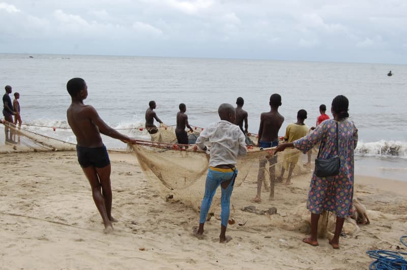
Yet Kribi is renowned for its fish. Customers come from the cities of Douala, Yaoundé and Bafoussam to stock up. A decline in fishing could have dramatic consequences for the fishermen of Kribi as well as on the food security of the cities they supply.
Elong and other Kribi fishers blame their declining catches on the Port Authority of Kribi (PAK), a Cameroonian state megaproject. Built by China Harbour Engineering Company, a subsidiary of Beijing-headquartered China Communications Construction Company Ltd. (CCCC), the massive port is intended to decongest the one at Douala and become a trade hub for all Central African countries. However, since the beginning of the port’s construction, an array of environmental problems have cropped up in the area. There’s the loss of fish, and also enhanced erosion of the coastline, an influx of people putting additional pressure on the area’s mangroves and infrastructure, more pollution, and new pressures on wildlife in the nearby marine protected area, Manyange na Elombo-Campo, the only one in the country.
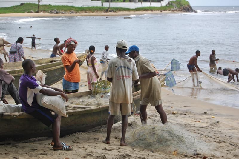
A decline in fishing could have dramatic consequences for the fishermen of Kribi as well as on the food security of the cities they supply. Image by Rifoeblaise via Wikimedia Commons (CC BY-SA 4.0).
Hard infrastructure, harder-hitting waves
In 2011, Paul Biya, Cameroon’s president, laid the foundation stone for the PAK, a gigantic project slated to be completed in four phases by 2040. When finished, the deepwater port complex will comprise 20 shipping terminals and 6.5 kilometers (4 miles) of quayside, able to handle 100 million metric tons of cargo per year. For now, only Phase 1 is complete. Located at Mboro, 30 km (19 mi) from Kribi town, it includes a total quay length of 615 meters (2,018 feet), a 1,355-m (4,446-ft) dike, buildings and roads. Phase 2 began in 2022: it will include, among other elements, a 700-m (2,296-ft) extension of the quay, a 675-m (2,215-ft) extension of the dike, an aluminum terminal and a hydrocarbon terminal on the dike, and more buildings and roads. Eventually there will be another smaller port terminal in Lolabé, around 5 km (3 mi) south of Mboro , for minerals.
The port is considered a success, generating 23 billion CFA francs ($38 million) in 2022, and transiting 5.3 million metric tons of goods in the first half of 2023. The association of West and Central African port operators, AGPAOC, even awarded it “Best quayside productivity” at the African Ports Awards in November 2023.
Yet this financial windfall has had an impact on the environment.
“Ever since the port was built, we’ve noticed that the waves are getting rougher and the sea is encroaching further and further towards the mainland,” Benjamin Ondo Obiang, a botanist, water pollution specialist and the coordinator of the Kribi-based NGO Promotion Circle for Forests and Local Development Initiatives (CEPFILD), who has worked in the area for almost 25 years, tells Mongabay. “From a scientific point of view, we can link this to the fact that the port’s infrastructures are hard. The more solid the infrastructure on the coast is, the more it activates the waves’ violence. As the sea becomes more aggressive, it ends up destroying the coastal fauna, and then the beaches. The entire biodiversity of this part of the coast is threatened.”
To attenuate the force of the waves, the PAK completed the 1,355-m dike in 2014. By absorbing part of the wave energy, it not only protects the coastline but also creates better conditions for boats to maneuver as they approach the docks. However, it has failed to stem coastal erosion. Kribi, like the rest of the world, is sensitive to climate change and its consequences; the town is particularly vulnerable to sea level rise, extreme weather events and flooding, according to Ondo Obiang.
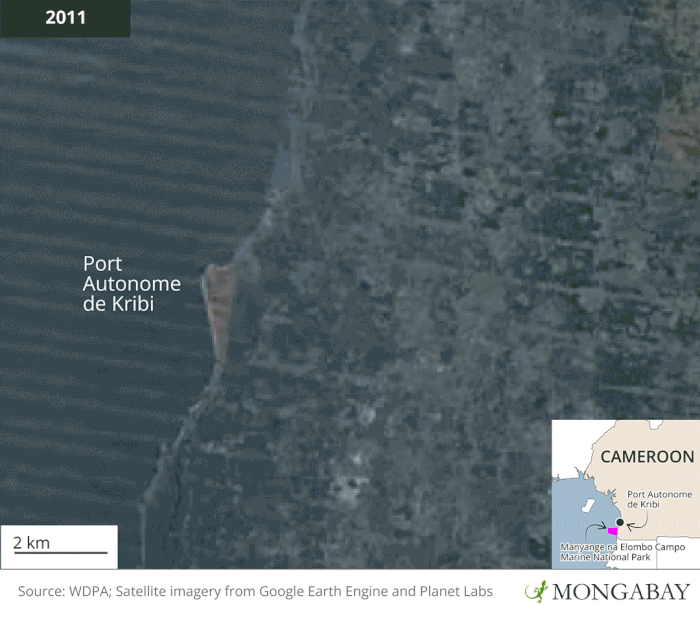
In 2022, a team of researchers from the University of Douala, the University of Yaoundé 1 and the University of Liège in Belgium compared satellite images of the Kribi coastline before and after the construction of the port, and measured coastal erosion using GPS. The results, published in a study, are revealing. Between 1973 and 2000, the coastline gained around 0.4 m (1.3 ft) of sediment per year. Then, with the construction of the port, erosion began: Between 2000 and 2015, the coastline began to shrink by 0.9 m (almost 3 ft) a year. And from 2015 to 2020, after the port became operational, the coastal area shrank by around 2 m (6.5 ft) per year.
But that doesn’t mean the dike is ineffective. Maps in the study show that some areas have gained up to 15 m (49 ft) of sand, while others have lost just as much, particularly between the port and the village of Lolabé to the south. The dike is therefore creating a sawtooth-shaped coastline by trapping sediment downcurrent of the Kribi port, according to the study.
The PAK declined Mongabay’s request for an interview to respond to the concerns expressed by scientists and fishermen, instead sending a statement: “[W]e have focused on reducing the impact on marine biodiversity. Achieved in 2020: Environmental studies, including hydro-sedimentary studies and Port preservation plans, have led to the development of a pollution control plan, as well as plans for the restoration of natural environments. Following this study, an environmental monitoring program was set up, enabling us to acquire and install on-site equipment for monitoring natural environments. We have, for example, installed a DB8000 buoy to collect environmental data at sea, and equipment to monitor the quality of groundwater, surface water and air. In addition, several framework agreements have been signed with research institutions such as IRGM [the Geological and Mining Research Institute], or the University of Yaoundé 1 and its various laboratories, dedicated to the study and monitoring of environments.”
The PAK did not respond to Mongabay’s request for further information about the results of these studies and what is planned in the framework agreements. The PAK communications team also denied Mongabay’s request for access to an environmental and social impact study carried out related to the PAK construction that includes, as the law requires, measures to mitigate the impact of the port.
The mangrove forests, unique ecosystems at the boundary between land and sea, not only protect the coast but also store more carbon than tropical rainforests hectare for hectare. Image by Jon Bowen via Flickr (CC BY-NC-ND 2.0).
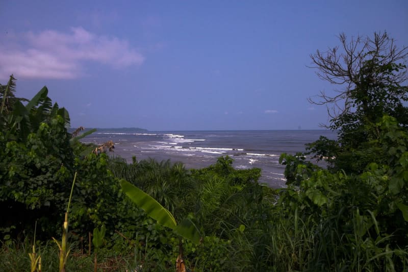
Kribi, like the rest of the world, is sensitive to climate change and its consequences; the town is particularly vulnerable to sea level rise, extreme weather events and flooding. Image by Rifoeblaise via Wikimedia Commons (CC BY-SA 4.0).
Loss of protective vegetation
The dike isn’t the only way the PAK is influencing beach sedimentation. Damage to protective coastal vegetation weakens the coastline and exposes it to erosion. The 26,000-hectare (64,200-acre) PAK site at Mboro was originally mainly coastal forest as well as mangrove swamp, but the construction of port facilities has led to significant deforestation of both, which is already clearly visible via satellite.
In addition, the port construction portends significant demographic growth in the town of Kribi and its surroundings, which will impact environmental dynamics. By 2026, the port expects to generate 15,000 direct jobs and around 25,000 indirect jobs, which will attract new workers to Kribi. The town’s residential area will be home to around 300,000 people by 2040, according to the PAK’s estimates, more than triple its current population. The high demand for housing will lead to the extraction of sand, much of which will come from the beaches. This will increase the beaches’ slope and therefore the erosive action of the waves, which will then further reduce the beaches’ area, according to Ondo Obiang.
“If you go to Kribi, you’ll see that all the plants and trees that used to line the beaches of some of the busiest beaches are falling over … As they fall, they leave the beach bare and erosion intensifies,” Ondo Obiang says. “It’s like a snake biting its own tail. The road entering Kribi is threatened, and houses are being destroyed along the beaches. It’s really dangerous.”
The demographic growth brought about by the port’s construction is also driving demand for smoked fish, a dietary staple throughout Central Africa, which is further impacting the mangroves. Mangrove wood is used to build fishers’ huts and dugout canoes, but above all as fuel for smoking the fish. Yet mangrove forests, unique ecosystems at the boundary between land and sea, not only protect the coast but also store more carbon than tropical rainforests hectare for hectare. They also serve as a breeding ground for numerous marine species, including those traditionally consumed by Cameroonians, and are home to several species of sea turtle, including the green turtle (Chelonia mydas), the olive ridley turtle (Lepidochelys olivacea) and the hawksbill turtle (Eretmochelys imbricata). If Kribi’s mangrove disappears, so will the species it supports.
Mongabay reached out to the Ministry of Livestock, Fisheries and Animal Industries for an interview regarding its response to the fishers’ allegations that the port has contributed to declining fish stocks, but it didn’t respond.
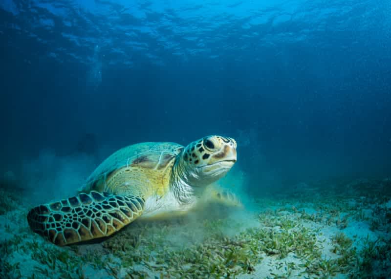
A green sea turtle. Among other measures implemented to protect marine life is the installation of a multifunctional buoy for monitoring environmental information and to support the study and protection of sea turtles. Image by Jack via Flickr (CC BY-NC-ND 2.0).
A park polluted
Part of the mangrove is officially preserved in Manyange na Elombo-Campo National Marine Park, Cameroon’s only marine protected area. It was established in 2021 to mitigate the port’s effects on the area’s marine life, according to Jules Romain Ngueguim, head of research at the Ministry of Science and Innovation’s Centre for Marine Ecosystems (CERECOMA). Among other measures implemented to protect marine life is the installation of a multifunctional buoy for monitoring environmental information and to support the study and protection of sea turtles, according to the PAK communications team.
“This marine park will be considered as a refuge zone and will ensure local populations with fishing-related activities,” Ngueguim, who was part of the team of scientists who inventoried the area’s biodiversity prior to the park’s establishment, tells Mongabay.
Covering 110,300 hectares (272,600 acres), the park is home to Lobé Falls, the only place in the world where a river ends its journey cascading into the sea over a series of waterfalls, according to UNESCO. It’s in the process of being designated a World Heritage Site by that same U.N. agency. The 2021 decree establishing the park states that its aims include “limiting the incursion of industrial fishermen who deplete the sea of fish, protecting spawning grounds and preserving certain fish species such as the marine turtle.”
The park’s management team was appointed only in June 2023, and protections have yet to be implemented. According to Ngueguim, the main reason is a lack of resources from the Cameroonian government. “The Marine Park Development Plan, which should take stock of biodiversity and assign functions to different zones, taking into account the aspirations of local communities, has neither been completed nor is it underway. It is urgently needed.” Ngueguim says. “For example, the boundaries of the park need to be marked out to prevent intrusion by ships, and fishing zones need to be defined … Except that to do so requires funds, and the country is currently going through a difficult economic period.”
The park is located just 30 km from the port. Disturbances generated by the port therefore affect the protected area, such as coastal erosion. And researchers are already observing the impact of port activity on certain marine species.
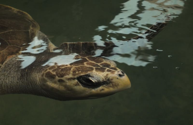
An olive ridley turtle. When the bags find their way into the sea, turtles often mistake them for their main food, jellyfish. Image by Siddarth Machado via Flickr (CC BY-NC 2.0).
“At Ebodje [a village in the park], where we monitor turtle egg laying, the beach is disappearing, which means that fewer and fewer turtles are coming to lay their eggs, and therefore there are fewer and fewer turtles,” says Jacques Fretey, a marine turtle expert with the IUCN who has been working in Kribi for more than 25 years and who was involved in the park’s creation. “These turtles are going to lay their eggs elsewhere, in Equatorial Guinea, and the park is losing its rich biodiversity, which is a real shame,” Fretey tells Mongabay.
The park is also experiencing pollution that’s at least indirectly attributable to the population growth caused by the port. Although Cameroon in 2013 banned the manufacture, possession, sale and distribution of thin, nonbiodegradable plastic bags and the granules used to make them, the bags continue to be illegally imported from neighboring countries and Cameroon faces a dire plastic pollution problem. When the bags find their way into the sea, turtles often mistake them for their main food, jellyfish.
“When the turtles come back from the Kribi area, sometimes they arrive tired, with oil stains and they die,” Ondo Obiang says. “When we cut open their bellies, we find plastics and garbage in their stomachs.”
Certain fish also eat the bags, before being consumed by larger fish and humans. So the plastic waste affects the whole food chain.
The park is also exposed to oil pollution. Now that the port is up and running, with its container terminal open to vessels carrying up to 8,000 containers, shipping traffic is intensifying in the area. Elong says he’s already observed the results while fishing outside the park. “More and more, you see oil slicks floating on the water. When I see one, I know that a boat has just been refueled and dumped its waste into the water. It’s becoming more and more common, and it’s not good — it scares the fish away,” he says.
There’s also a risk of heavy pollution in the event of a spill from oil platforms and oil exploration projects in the area, including the offshore export terminal for the Chad/Cameroon Petroleum Development and Pipeline Project, a 1,070-km (665-mi) pipeline that transports oil from Chad.
In its statement to Mongabay, the PAK wrote that Manyange na Elombo-Campo “is the subject of much interest from the PAK, in terms of the compensation measures to be developed. A draft framework agreement with the Ministry of Forests and Fauna (which oversees the Marine Park) is being drawn up for this purpose. Other actions include the acquisition of anti-pollution equipment to intervene in the event of hydrocarbon spills (absorbent rollers, socks, etc.), support for NGOs working to preserve marine biodiversity, and the reforestation of mangrove forests.”
For Fretey, however, this isn’t enough. In his view, the port and the marine park authorities need to work together to reduce the risk of pollution. “I had asked the minister for a port tax so that we could take care of the park, but it was refused. At the moment, the park’s curator doesn’t have enough money to take care of it. There needs to be an agreement between the park and the port,” Fretey says.
Meanwhile, construction of the PAK continues: A freeway between Douala and Yaoundé is just around the corner, and the dike is expanding steadily. Yet solutions to preserve biodiversity and the marine environment are slow to emerge, according to scientists and local people. This project was intended to bring greater wealth and development, but Sam Elong and other fishers continue to see the Kribian coastline shrinking and fish becoming scarce.
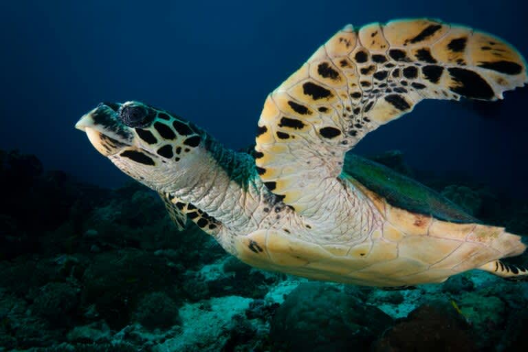
Banner image: The mangrove forests serve as a breeding ground for numerous marine species, including those traditionally consumed by Cameroonians, and are home to several species of sea turtles, including the hawksbill turtle. Image by Kris-Mikael Krister via Unsplash (Public domain).
Citation:
Mbevo Fendoung, P., Tchindjang, M., & Hubert-Ferrari, A. (2022). Weakening of coastlines and coastal erosion in the Gulf of Guinea: The case of the Kribi coast in Cameroon. Land, 11(9), 1557. doi:10.3390/land11091557
This article was originally published on Mongabay