By Aimee Gabay


A recent report has revealed a spike in deforestation in the buffer zone of one of the world’s best-protected areas, Peru’s Amarakaeri Communal Reserve.
Between 2001 and 2023, 19,978 hectares (49,367 acres) of forest were lost in the buffer zone of the reserve, which is home to the ancestral lands of the Indigenous Harakbut, Yine and Matsiguenka peoples. According to the report by the Monitoring of the Andean Amazon Project (MAAP), there are several factors for this trend, including illegal mining, coca cultivation and creation of landing strips, and new road developments.
Amarakaeri is co-managed by ECA Amarakaeri, an Indigenous organization representing the communities in its buffer zone, and SERNANP, the Peruvian agency for protected areas. It’s home to many threatened and endemic species, such as harpy eagles (Harpia harpyja) and spectacled bears (Tremarctos ornatus), and in 2018 was named to the Green List of the IUCN, the global nature conservation authority, for sites that are “effectively managed and fairly governed, with long-term positive impacts on people and nature.”
“About five years ago, probably the most threatened protected area used to be the Tambopata National Reserve,” said Sidney Novoa, a co-author of the MAAP report and director of conservation technology at the Peruvian NGO Conservación Amazónica–ACCA. “But in the last few years, Amarakaeri has scaled up in this list of most threatened protected areas in southern Peru. If the pressure increases, they are going to eventually lose this [IUCN Green List] category.”
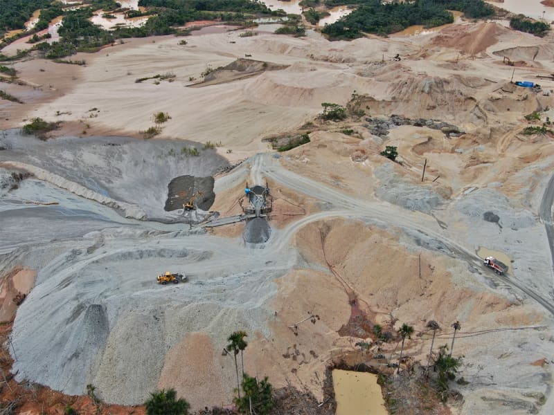
Illegal activity in the buffer zone of the Amarakaeri Communal Reserve in Peru. Image courtesy of Amarakaeri.org.
In Sabaluyoc and Itahuanía, to the south and southwest of the reserve, illegal cultivation of coca to produce cocaine is the main driver of deforestation. Between 2017 and 2022, the amount of land around Amarakaeri covered by illegal coca crops increased by almost 160%, according to data from DEVIDA, Peru’s anti-drugs commission.
“The issue of illicit crops in the southwest is something that worries us,” Novoa said. “For now, the people involved in this activity have enough land outside of the protected area to produce coca. If the threat continues over time, they will probably reach inside the [protected] area.”
Walter Quertehuari Dariquebe, the ECA Amarakaeri president, told Mongabay that to “clash with the issue of drug trafficking is to seek your death.” He added, “What do we do?”
It’s not just illegal activity driving the deforestation in Amarakaeri: according to the MAAP report, construction of the Nuevo Edén–Boca Manú highway in the northwest sector of the reserve has led to the loss of 407 hectares (1,000 acres) of primary forest since the project started in 2015.
More recently, the government proposed a new 96-kilometer (59-mile) extension to the highway, from Boca Manú to Boca Colorado. The MAAP report warns this could impact Amarakaeri and other protected areas, such as Manú National Park and Madre de Dios Territorial Reserve, as it would allow organized crime groups easier access to those areas, endangering the lives of Indigenous peoples living in voluntary isolation who also pass through this sector. If the project is approved, the MAAP estimates it could result in more than 11,350 hectares (28,000 acres) of deforestation over the next 10 years.

Local forest surveillance teams use a drone to carry out monitoring work at Peru’s Amarakaeri Communal Reserve. Image courtesy of Amarakaeri.org.
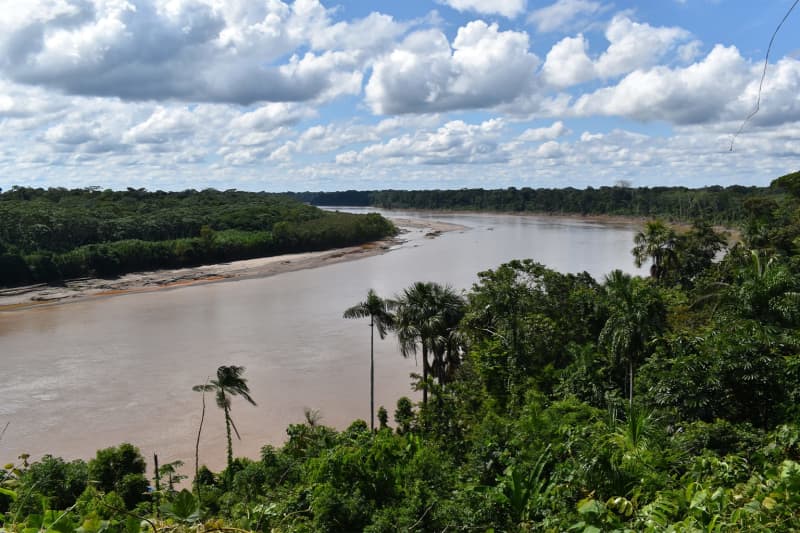
The Madre de Dios River observed from the Harakbut Indigenous community in the Amarakaeri Communal Reserve buffer zone. Image courtesy of Amarakaeri.org.
In 2023, Indigenous leaders from Madre de Dios issued a public statement urging the Peruvian Congress to reject a bill that would declare the proposed Boca Manú–Boca Colorado extension, as well as other road projects in the country, as being of national interest. They said this would violate “our collective rights to the territory, to prior consultation, to the life of our brothers in isolation and initial contact and ignores our opinion as Indigenous organizations representative of Madre de Dios.”
They also wrote in their statement that they aren’t “against development projects for our region. However, we consider it important that development includes our vision and protection of the territory.”
Besides the expansion of illegal coca production and new road projects, the MAAP report also identified illegal mining within the buffer zone east of Amarakaeri. Quertehuari Dariquebe blamed the mining activity for contamination of nearby water sources, poisoning fish and local communities. Because of this, he said, members of the community are suffering from health issues and babies are being born with serious health defects.
Quertehuari Dariquebe said the state is doing “practically nothing” to deal with the problems in the reserve’s buffer zone where Indigenous communities live and are most affected. The effects could easily spread inside the reserve if issues there continue unabated, he added.
“There is still a large gap for surveillance and control actions in protected natural areas and their buffer zones to be more effective,” Fredy Mamani, head of the Amarakaeri Communal Reserve, told Mongabay. “SERNANP together with the ECA Amarakaeri have already been making efforts to reduce these gaps in the Amarakaeri Communal Reserve, but our institution does not exercise control in the buffer zone and influence where these threats arise.”
Banner image: Amarakaeri Communal Reserve is home to many threatened and endemic species, such as harpy eagles. Image by Nathan Rupert via Flickr (CC BY-NC-ND 2.0).
Feedback: Use this form to send a message to the author of this post. If you want to post a public comment, you can do that at the bottom of the page.
This article was originally published on Mongabay