New Jersey will experience a brief return to spring this afternoon, with partly sunny skies and temperatures warming up to the high 60s, but a surge of colder air from Canada later Wednesday will make it feel more like early March instead of late April.
Forecasters say temperatures will likely drop below the freezing mark overnight Wednesday into early Thursday in northern sections of the state, posing a threat to sensitive outdoor plants and outdoor pipes during the early phase of the growing season.
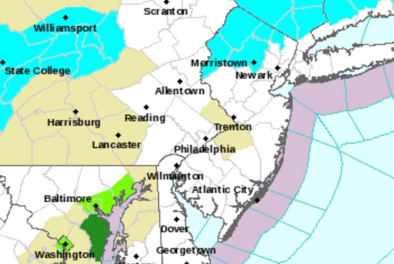
As a result, the National Weather Service has issued a freeze watch for five counties — Morris, Sussex, Warren, western Bergen and western Passaic. Those areas of the Garden State could see lows dipping down to 30 or 31 degrees.
UPDATE: The freeze watch has been upgraded to a freeze warning for Morris, Sussex, Warren, western Bergen and western Passaic, and a frost advisory has been issued for Hunterdon County. All of those alerts are active from 3 a.m. to 9 a.m. Thursday.
“Frost and freeze conditions could kill crops, other sensitive vegetation and possibly damage unprotected outdoor plumbing,” the weather service’s New York regional office said.
“To prevent freezing and possible bursting of outdoor water pipes, they should be wrapped, drained, or allowed to drip slowly,” the weather service noted. “Those that have in-ground sprinkler systems should drain them and cover above-ground pipes to protect them from freezing.”

Although it will be cold Thursday morning, forecasters say steady winds may prevent air temperatures on the ground from dropping into the 20s, like they did in some areas of the state Monday morning and Tuesday morning.
“Cool air is expected to linger across our region Thursday afternoon, keeping temperatures in the 50s even though skies will be mostly sunny,” the weather service’s Mount Holly office said. “An onshore wind will keep it even cooler along the coastal areas.”
Temperatures will likely drop into the low to mid-30s overnight Thursday into Friday morning, posing another risk of frost or freezing.
With mostly sunny skies Friday afternoon, temperatures should climb into the low 60s. Similar highs are expected on Saturday, with partly sunny skies, before a noticeable warmup occurs on Sunday, with partly sunny skies and highs reaching the mid- to upper-70s.
Temperatures could make a run for 80 degrees on Monday, with some areas of New Jersey getting close to 85 degrees, according to the weather service’s long-range forecast.
Current weather radar
Thank you for relying on us to provide the local weather news you can trust. Please consider supporting NJ.com with a voluntary subscription.
Len Melisurgo may be reached at LMelisurgo@njadvancemedia.com or on X at @LensReality.